
Providing help for scientific projects is one of the main purposes of Glacier Adventure.
We can, for example, provide material or guidance. In this article we will present to you one of the projects, named IceAq, conducted by a collaboration between the University of Iceland and a French team of the ENS Geosciences lab. This research is granted by EU, PHC-Jules Verne and PSL-Global SEED.
The aim of the project is to understand the impact of climate change on glacial aquifers through the case of southern Iceland.
But first of all, what is an aquifer?
To make it simple, an aquifer is a rock layer that contains water, the water fills the pores of the rocks. All rocks have different permeability and porosity characteristics, and these have an impact on the water’s way of moving under the ground. This explains that there are different types of aquifers, depending on the nature of the rocks.
Why is it important to understand the impact of climate change on aquifers?
Simply because aquifers are one of the most important sources of freshwater on Earth and also because we can drill well on many types of aquifer. It’s essential to understand how the water resources of aquifers will evolve with climate change to anticipate the future of water management. It is even more critical in this area because even if glaciers are now well known because they are well studied, the groundwater component is rarely considered and studied. It is also useful to forecast potential floods and landslide hazards.
How are field studies carried out?
The biggest part of the research isn’t really on the field because it consists of analyzing data and creating a computer model to understand and link different factors. But to achieve this, it is necessary to collect information and data directly on the field.
We will present you 2 examples of methods to collect data:

The first one is collecting data about the water thanks to bore holes. It permits you to see the water level in different areas and also the water characteristics, depending on the rock type, the proximity of the ocean, or other characteristics of the ground. To collect those data, scientists use a calibrated probe and a measuring tape. Collecting it regularly at different times of the year allows to create a good database to study the groundwater and aquifers. It is also important to have different drilling and different areas to compare data and to have a better overview of the groundwater system area.
In the case of the IceAq project, the boreholes are in different areas, near Fláajökull, Skálafellsjökull and in Hali right next to our meeting point !
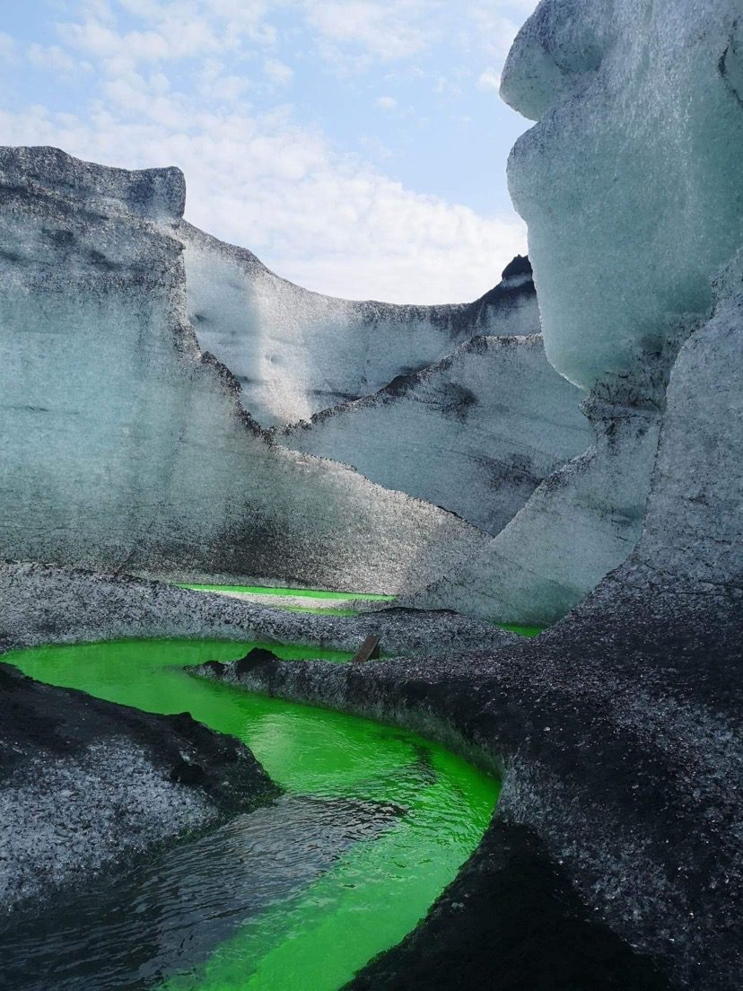
The second one is dye tracing, this method consists of putting some dye in the water to determine characteristics of the groundwater system. To collect data about the dye in the water, a fluorometer is used. Dye tracing is useful to analyze the flow of the water, to calculate the speed and also to see the dispersion of the dye.
For the IceAq project, the dye had been injected in a Moulin of a glacier (a nearly vertical channel in ice that is formed by flowing water) by one team. Another team installed a fluorometer in the glacier river, far from the injection point to collect data. Here, they are looking for a concentration of dye in the river, the resurgence point, the time between the injection and the detection of the dye several meters away. All that data allowed them to create a model of the groundwater system of the glacier and repeating these operations at different times of the year can provide information about the impact of climate change and glacier melting on the aquifer and on water resources. This method was used several times on Breiðamerkurjökull and Skálafellsjökull.

Detection point in the river

Injection point on Breiðamerkurjökull
To complete data collecting, seismometers have been installed near the river to estimate the water flow. Indeed, a seismometer can detect the impact of the water on the river bed and thus permits calculation. For the same purpose, a time lapse camera has been installed on a bridge under the Skálafellsjökull river. It needs a good calibration method to estimate the water flow from pictures. This camera will stay all year long to observe the river’s evolution depending on the season and on the glacier melting.
At this moment, the research is still progressing but some results are already conclusive. Indeed, firsts data collected in the boreholes allowed to identify 2 distinct aquifers, one in the till and glacial-fluvial deposits and one in the basalts. They have different characteristics about water temperature and conductivity, recharge, discharge and other parameters. This means that the two must be studied separately but also in parallel to understand interdependencies.
If you are interested in this subject and you want to know more: https://egusphere.copernicus.org/preprints/2023/egusphere-2022-1442/
We hope you enjoyed this little presentation and maybe learned something!